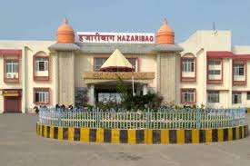
Hazaribagh

Hazaribag is a district in the Indian state of Jharkhand, known for its rich natural resources, scenic beauty, and historical importance. Here’s a detailed overview of the Hazaribag district:
1. General Information
State: Jharkhand
Division: North Chotanagpur
District Headquarters: Hazaribag town
Area: Approx. 3,555 sq km
Official Languages: Hindi, Khortha, Nagpuri, Urdu
Population (2011 Census): Approx. 1,734,495
Literacy Rate: Around 69.75%
Major Rivers: Konar, Damodar, Barakar
2. Historical Background
Hazaribag’s name is believed to be derived from “Hazar” (a thousand) and “Bagh” (gardens), implying “a place of a thousand gardens.” The region has historical roots dating back to ancient times and was part of the Magadh Empire. During British rule, it was part of the larger Chotanagpur region.
Significant developments occurred during the colonial era, including the establishment of Central Jail in Hazaribag, which housed several freedom fighters including Jayaprakash Narayan.
3. Geography and Climate
Terrain: Mostly plateau and forested, with some hills
Climate: Subtropical — Hot summers, cold winters
Rainfall: Average annual rainfall ranges between 1,200–1,400 mm
The Hazaribag Plateau is a part of the Chotanagpur Plateau and is known for its scenic beauty and pleasant weather.
4. Administrative Divisions
Hazaribag is divided into the following administrative blocks:
Hazaribag Sadar
Katkamsandi
Bishnugarh
Barkagaon
Ichak
Daru
Keredari
Churchu
Chalkusha
Tati Jhariya
Barhi
5. Economy
Key Sectors:
Agriculture: Major crops include rice, maize, wheat, and pulses.
Mining: Rich in coal; part of the North Karanpura Coalfield. Many areas like Barkagaon and Keredari have mining activities run by CCL (Central Coalfields Limited).
Forestry and Cottage Industries: The district also has a tradition of handloom and handicrafts.
Hazaribag is part of the “Red Corridor,” meaning some regions have been affected by Naxalite (Maoist) activities, which impact development efforts.
6. Education
Hazaribag has long been an educational hub of North Jharkhand, with several institutions of repute:
Vinoba Bhave University – The primary university of the region.
St. Columba’s College – Established in 1899, one of the oldest colleges.
Medical College – Hazaribag Medical College (Government-run).
Engineering Colleges – Several private and government institutions.
7. Tourism and Places of Interest
Natural Attractions:
Hazaribag Wildlife Sanctuary – One of the oldest sanctuaries, home to wildlife like sambar, nilgai, and sloth bear.
Canary Hills – Scenic viewpoint near Hazaribag town.
Rajrappa Temple – A famous Chhinnamasta temple near the Damodar river, about 70 km from Hazaribag.
Cultural/Historical Sites:
Silwar Jail – Historic prison where freedom fighters were jailed.
Narsigsthan – A religious and archaeological site.
Konar Dam – A large dam built on the Konar River, ideal for picnics and nature enthusiasts.
8. Transport and Connectivity
Rail: Hazaribag Town railway station is part of the Koderma–Hazaribag–Barkakana–Ranchi line.
Road: Well-connected via NH-33 and NH-100 to Ranchi, Patna, and Kolkata.
Air: The nearest airport is Ranchi (Birsa Munda Airport), around 100 km away.
9. Culture and Festivals
Hazaribag is culturally diverse, with tribal and non-tribal communities coexisting. Important festivals celebrated here include:
Chhath Puja
Durga Puja
Diwali
Sohrai and Karma – Tribal festivals
Eid – Observed by the large Muslim population
Folk dances, traditional music, and tribal arts are an integral part of the region’s cultural identity.
10. Challenges and Development
Challenges:
Naxalite influence in some areas
Inadequate healthcare facilities in rural zones
Unemployment and migration issues
Development Efforts:
Government and private investment in mining and energy
Road and rail infrastructure improvements
Educational uplift through new institutions
If you’d like, I can also provide a tourist itinerary, economic development proposal, or presentation slides about Hazaribag. Let me know your use case!
